Drone operators
Deliver the whole drone project, not a folder of files.
You already fly the mission and process the data. SpearAtlas is the workspace where those outputs become one client-ready project—maps, models, media, and documents in a single shareable experience.
No credit card required · Free plan includes 5 GB
The delivery problem
Capture is finished. Delivery is still a pile of links.
A commercial mapping job rarely ends as a single file. After processing you may have a GeoTIFF orthomosaic, a LAS or LAZ cloud, an OBJ or GLB mesh, a JPEG still set, an MP4 fly-through, and a PDF report. Those files usually land in Drive, Dropbox, email, or a generic share folder—each with a different link and no project story around them.
Clients then download formats they cannot open, or they ask which file is the map, which is the model, and which is the report. You spend the next hour explaining software they do not have, instead of walking them through the site.
SpearAtlas does not fly the drone or run photogrammetry. It receives the outputs you already produce and holds them in one project so the handoff matches the work you actually did.
- Separate links for maps, models, video, and PDFs
- Clients downloading specialist files they cannot inspect
- Project context stripped away from the files
- Repeat sites arriving as disconnected deliveries
How SpearAtlas fits
The delivery layer after processing
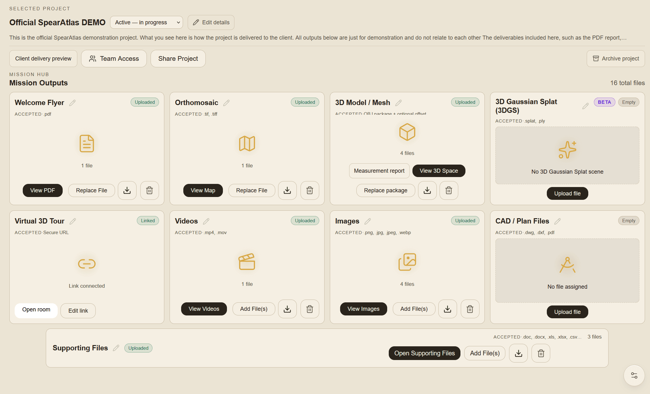
Your capture app, flight planner, and photogrammetry software stay where they are. When the orthomosaic, mesh, cloud, and media are ready, you upload them into a SpearAtlas project and arrange them in Mission Hub rooms.
From there you preview the client experience, share one project link, and let reviewers move between the map, the 3D Space, imagery, video, and supporting files without assembling the package themselves.
Capture / process
Your drone, scanner, photogrammetry, or reconstruction software produces the files. SpearAtlas is not in this step.
Step 1 of 4Organize in SpearAtlas
Upload the outputs into Mission Hub rooms so maps, models, media, and documents sit on the same project.
Step 2 of 4Deliver
Preview the client experience, then share one project link instead of a chain of folders.
Step 3 of 4Client views
Recipients review supported files in the browser, with the project context still attached.
Step 4 of 4
Relevant deliverables
Formats this workflow typically brings in
Typical drone mapping packages include several of these supported outputs. Upload what the job produced—SpearAtlas opens each type in the matching room.
- GeoTIFF / TIFFOrthomosaic map rooms for hosted GeoTIFF review.
- LAS / LAZOptional aligned point-cloud layers in Space.
- OBJPhotogrammetry meshes in the 3D Space room.
- GLB / GLTFTextured 3D models for site and structure review.
- PLYPoint-cloud layers, or Gaussian splat PLY in the 3DGS room.
- SOGBetaGaussian splat package for the dedicated 3DGS room.
- SPLATBetaGaussian splat files for browser preview in 3DGS.
- JPEG / PNG / WebPInspection photos, progress stills, and supporting imagery.
- MP4Hosted project and progress video in a dedicated room.
- PDFReports and plan PDFs delivered with the same project.
- CSVTables and field notes kept with supporting files.
- DOC / DOCXWritten reports and scope notes in supporting files.
- XLS / XLSXSpreadsheets attached to the same mission workspace.
In the workspace
Capabilities that apply here
One project for the whole mission
Keep the orthomosaic, 3D outputs, stills, video, and documents on the same Mission Hub instead of splitting them across folders.
One project for the whole mission in SpearAtlas →Orthomosaic viewer
Host GeoTIFF maps so clients can pan and zoom the site in the browser instead of wrestling with a local GIS install.
Orthomosaic viewer in SpearAtlas →3D model viewer
Present OBJ, GLB, or GLTF meshes in Space, with optional LAS/LAZ or PLY layers when the job includes a point cloud.
3D model viewer in SpearAtlas →3D Gaussian splat viewer
When the job includes a splat, the dedicated 3DGS room previews SOG, SPLAT, or Gaussian PLY files. 3DGS is Beta.
3D Gaussian splat viewer in SpearAtlas →Imagery and video with the maps
Still sets and MP4 walkthroughs stay attached to the same project as the spatial outputs, so the client sees how the site was captured.
Imagery and video with the maps in SpearAtlas →A single client project link
Send a curated, read-only project instead of a chain of downloads. Preview the delivery before it leaves your workspace.
A single client project link in SpearAtlas →
A typical project
A typical mapping delivery
A 40-acre site flown for a civil client. Pix4D or Metashape has already produced the ortho, the dense cloud, and a textured mesh. The operator still has nadir stills, a short site video, and a two-page PDF summary.
Capture and process
Fly the grid, process in your photogrammetry software, and export the GeoTIFF, LAS/LAZ, and mesh you already trust. SpearAtlas is not in this step.
Upload into one project
Create the job in SpearAtlas. Place the ortho in Maps, the mesh and optional cloud in Space, stills in Images, the clip in Video, and the PDF with supporting files.
Organize the rooms
Title the cards the way you talk about the job—Site ortho, Existing conditions model, Flight stills—so the client is not guessing file names.
Share the project
Open Client Delivery Preview, then send one link. The client reviews the map, orbits the model, and reads the report without installing QGIS or CloudCompare.
Continue
Related workflows and product pages
- Surveying & MappingHand off orthos and models clearly.
- Reality CaptureShare models, splats, and point clouds.
- InspectionsGive findings spatial context.
- See plans and storageSpearAtlas product
- How Mission Hub is structuredSpearAtlas product
- Client-facing deliverySpearAtlas product
Back to SpearAtlas homeView pricing
Related guides
- How to Review a Point Cloud Before Delivering It to a ClientA practical workflow for reviewing an exported LAS or LAZ point cloud before client delivery, including orientation, attributes, coordinates, a distance check, and keeping the original file.
- Point Cloud vs 3D Mesh vs Gaussian Splat: Which 3D Deliverable Should You Use?Compare point clouds, 3D meshes, and Gaussian splats for drone mapping and reality capture, including measurement, visualization, file formats, accuracy, client delivery, and when to use each.
- GCPs vs Checkpoints in Drone Mapping: What Is the Difference?Learn the difference between ground control points and checkpoints in drone mapping, including how they affect photogrammetry accuracy, RTK workflows, control distribution, residuals, and independent verification.
Get started
Bring your next drone project into one workspace.
Upload the outputs you already produce, arrange them once, and send a project link your client can actually open.