Reality capture
One workspace for the outputs of reality capture.
Modern jobs increasingly ship more than one model of the same site. SpearAtlas receives those outputs—meshes, point clouds, Gaussian splats (Beta), orthomosaics, and media—and presents them as a single project for review and delivery.
No credit card required · Free plan includes 5 GB
The delivery problem
Multiple representations, too many places to look.
A capture program might produce a dense LAS/LAZ, an OBJ or GLB mesh, a Gaussian splat, a GeoTIFF, and a still set. Each format answers a different question: measurement, texture, visual presence, planimetric context, close-up evidence.
When those files live in separate viewers and folders, the client never sees them as one record of the space. You become the router between CloudCompare, a mesh tool, a splat viewer, and a map.
SpearAtlas does not run the reconstruction. It does not replace your scanner software, photogrammetry package, or splat training pipeline. It is the project layer after those tools export.
- Meshes, clouds, and splats sent as unrelated links
- Clients who can open one format and not the others
- Orthos and photos drifting away from the 3D record
- No shared project around the capture
How SpearAtlas fits
Hold every representation of the space
Put the mesh in Space, optional LAS/LAZ or PLY as point-cloud layers, and Gaussian SOG, SPLAT, or splat PLY in the dedicated 3DGS room. Host the ortho in Maps. Keep stills, video, and PDFs in their rooms.
The client moves between those views inside one project. 3D Gaussian splat viewing is Beta; label it that way when you deliver it.
Capture / process
Your drone, scanner, photogrammetry, or reconstruction software produces the files. SpearAtlas is not in this step.
Step 1 of 4Organize in SpearAtlas
Upload the outputs into Mission Hub rooms so maps, models, media, and documents sit on the same project.
Step 2 of 4Deliver
Preview the client experience, then share one project link instead of a chain of folders.
Step 3 of 4Client views
Recipients review supported files in the browser, with the project context still attached.
Step 4 of 4
Relevant deliverables
Formats this workflow typically brings in
Reality-capture packages often include several 3D types plus maps and media. These formats are supported today. 3DGS formats are Beta.
- OBJPhotogrammetry meshes in the 3D Space room.
- GLB / GLTFTextured 3D models for site and structure review.
- LAS / LAZOptional aligned point-cloud layers in Space.
- PLYPoint-cloud layers, or Gaussian splat PLY in the 3DGS room.
- SOGBetaGaussian splat package for the dedicated 3DGS room.
- SPLATBetaGaussian splat files for browser preview in 3DGS.
- GeoTIFF / TIFFOrthomosaic map rooms for hosted GeoTIFF review.
- JPEG / PNG / WebPInspection photos, progress stills, and supporting imagery.
- MP4Hosted project and progress video in a dedicated room.
- PDFReports and plan PDFs delivered with the same project.
In the workspace
Capabilities that apply here
Photogrammetry and mesh review
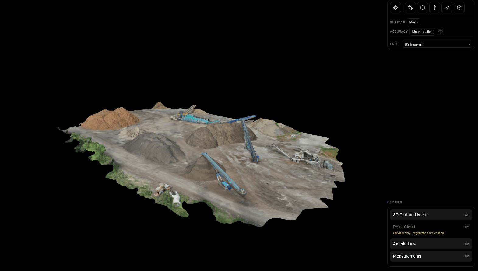
OBJ, GLB, and GLTF in Space for textured existing-conditions models, with 3D measurements on supported meshes.
Photogrammetry and mesh review in SpearAtlas →Dense clouds beside the mesh
LAS, LAZ, and PLY as optional Space layers when the capture includes a point cloud.
Dense clouds beside the mesh in SpearAtlas →3D Gaussian splats
Dedicated 3DGS room for SOG, SPLAT, and Gaussian PLY. This path is Beta and is not a replacement for mesh or cloud workflows.
3D Gaussian splats in SpearAtlas →Planimetric context
When the job includes a GeoTIFF, keep it in Maps so the 3D record has a 2D site view next to it.
Planimetric context in SpearAtlas →One project, several representations
Mission Hub is the index: each format in its room, one job, one client link.
One project, several representations in SpearAtlas →Let clients view without your toolchain
Share a curated project. Recipients review supported views in the browser instead of collecting four viewer apps.
Let clients view without your toolchain in SpearAtlas →
A typical project
A typical multi-representation job
An interior-plus-site capture for an architect. You have an OBJ mesh, a LAS cloud, a Gaussian splat for a visual walkthrough, a handful of stills, and a short PDF of capture notes.
Capture and reconstruct
Scan or photograph, then process in the tools you already use. Export the mesh, cloud, and splat independently. SpearAtlas does not train the splat or build the mesh.
Place each output
Mesh and cloud in Space, splat in the 3DGS room, stills in Images, notes as PDF. Title rooms so the architect knows which view to open first.
Preview as the client
Use delivery preview. Confirm the splat is labeled Beta if you include it, and that the mesh is the measurement surface you intend.
Share the project
One link. The architect can orbit the mesh, glance at the splat for presence, and read the notes without a software install conversation.
Continue
Related workflows and product pages
- Drone OperatorsDeliver complete mapping projects.
- Surveying & MappingHand off orthos and models clearly.
- ConstructionKeep site documentation together.
- 3D Space capabilitiesSpearAtlas product
- 3DGS room notesSpearAtlas product
- View pricingSpearAtlas product
Back to SpearAtlas homeView pricing
Related guides
- How to Review a Point Cloud Before Delivering It to a ClientA practical workflow for reviewing an exported LAS or LAZ point cloud before client delivery, including orientation, attributes, coordinates, a distance check, and keeping the original file.
- Point Cloud vs 3D Mesh vs Gaussian Splat: Which 3D Deliverable Should You Use?Compare point clouds, 3D meshes, and Gaussian splats for drone mapping and reality capture, including measurement, visualization, file formats, accuracy, client delivery, and when to use each.
- GCPs vs Checkpoints in Drone Mapping: What Is the Difference?Learn the difference between ground control points and checkpoints in drone mapping, including how they affect photogrammetry accuracy, RTK workflows, control distribution, residuals, and independent verification.
Get started
Put every model of the space in one project.
Meshes, clouds, Gaussian splats (Beta), maps, and media belong together. SpearAtlas is the workspace that holds them for delivery.