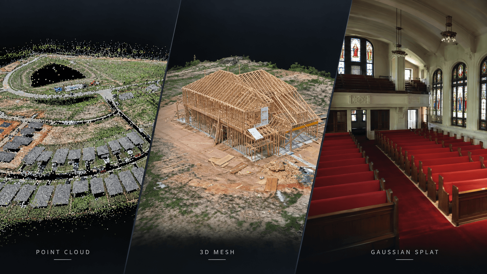
A modern reality capture project can produce several different representations of the same physical site.
Three of the most common are:
- Point cloud
- 3D mesh
- Gaussian splat
At first glance, they can look similar.
All three can represent a real place in three dimensions.
All three can be viewed interactively.
All three may originate from drone imagery, terrestrial photography, laser scanning, or other capture methods.
But underneath the viewer, they are fundamentally different.
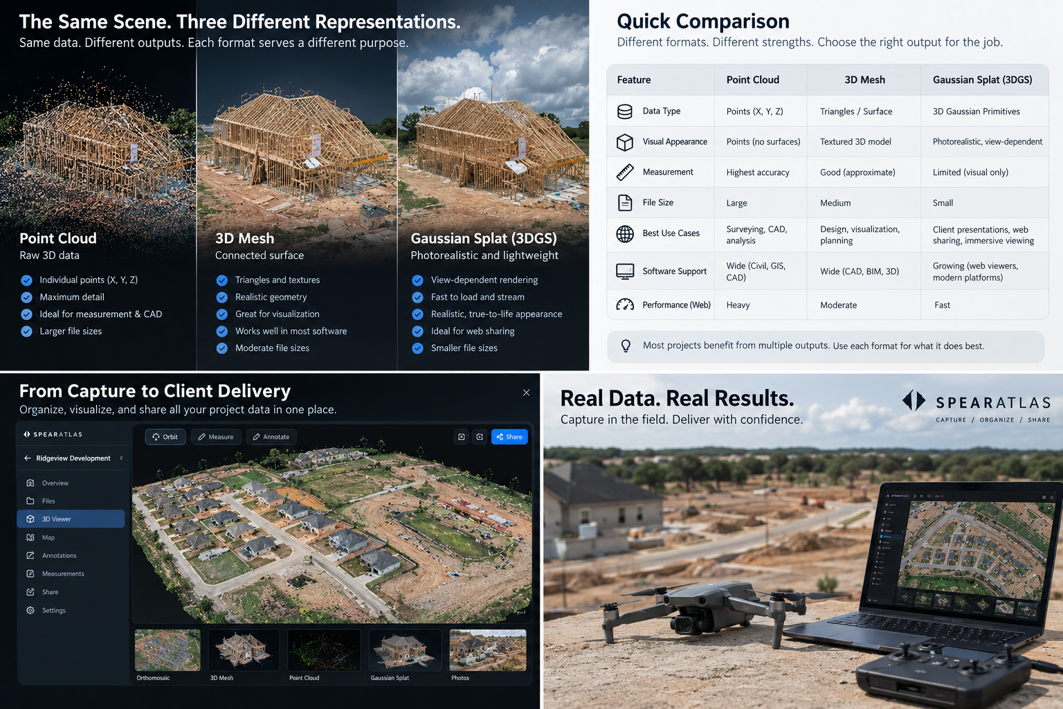
A point cloud stores discrete spatial points.
A mesh connects geometry into surfaces.
A Gaussian splat represents visual appearance using many spatial primitives.
Those differences determine what each format is good at.
Why the distinction matters
Imagine capturing the same construction site.
You could produce:
- A point cloud for measurable spatial data
- A textured mesh for a continuous 3D surface
- A Gaussian splat for highly realistic visual navigation
All three describe the same site.
They do not preserve the same type of information.
Choosing the correct deliverable therefore depends on what the recipient needs to do with the data. Drone mapping deliverables explained covers how these 3D products sit next to orthomosaics, elevation models, and reports.
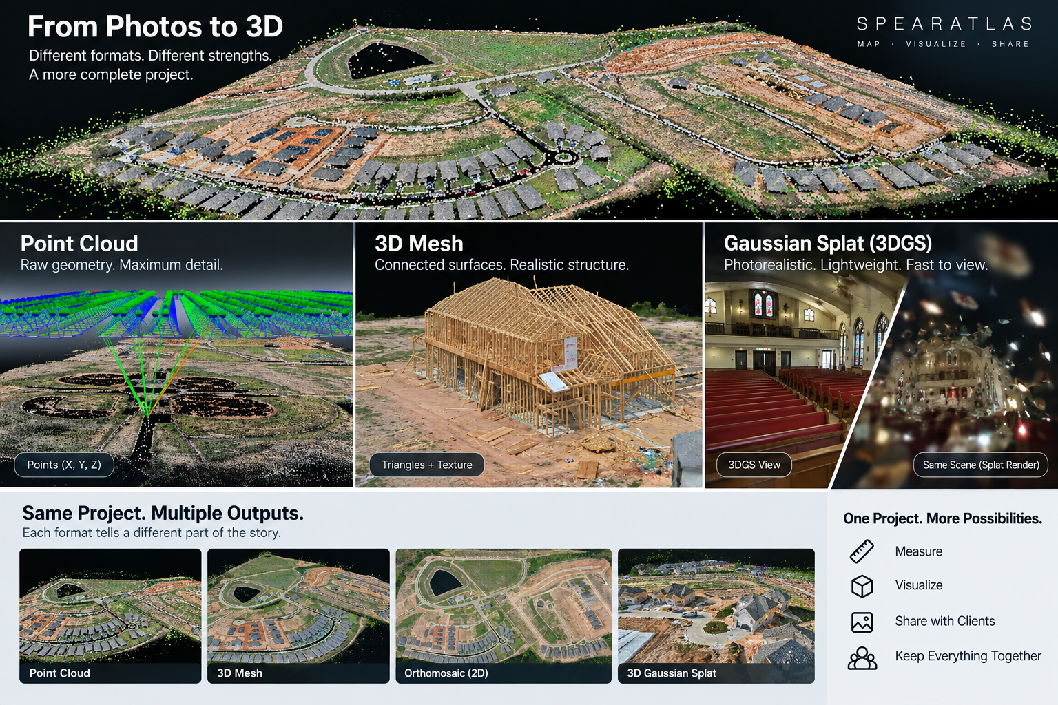
What is a point cloud?
A point cloud is a collection of individual points positioned in three dimensional space.
Each point has coordinates such as:
- X
- Y
- Z
Additional attributes may include:
- RGB color
- Intensity
- Classification
- Return information
- GPS time
- Other metadata depending on the capture method and file format
Together, millions of points form a sampled representation of visible surfaces. For a dedicated product explainer, see what a point cloud is.
Where point clouds come from
Point clouds commonly originate from:
- LiDAR
- Drone photogrammetry
- Terrestrial laser scanning
- Mobile mapping
- Structured light scanning
- Other reality capture systems
The capture method matters.
A LiDAR point cloud is generated differently from a photogrammetric point cloud even if both are eventually delivered in LAS, LAZ, or another point format. LAS vs LAZ covers those geospatial point formats.
What does a point cloud actually represent?
A point cloud does not create a continuous surface between every point.
Instead, it stores discrete measurements or reconstructed positions.
Think of it as millions of spatial samples.
Viewed together, those samples reveal:
- Terrain
- Buildings
- Stockpiles
- Pipes
- Vegetation
- Facades
- Equipment
- Other physical features
The density of the cloud determines how closely spaced those samples are.
Why point clouds are useful
Point clouds are useful when the spatial structure itself matters.
Typical applications include:
- Distance measurement
- Elevation analysis
- Clearance checks
- Cross sections
- Surface generation
- Stockpile analysis
- Terrain classification
- CAD reference
- BIM workflows
- Engineering context
- Asset documentation
A point cloud can preserve detailed three dimensional information without requiring the software to invent surfaces between every point. Surveying and mapping teams often keep the cloud because later GIS or CAD work depends on those points.
Limitations of point clouds
Point clouds can be difficult for nontechnical clients to understand.
Common limitations include:
- Very large files
- Specialized software requirements
- Dense visual appearance
- Gaps in coverage
- Noise
- Limited surface continuity
- Performance demands
A point cloud may contain excellent spatial data while still being difficult to present to someone who simply wants to understand what the site looked like.
What is a 3D mesh?
A 3D mesh represents surfaces using connected polygons.
The most common polygons are triangles.
Vertices describe positions in three dimensional space.
Edges connect those vertices.
Faces create surfaces between them.
The result is continuous geometry rather than a collection of separate points.
How photogrammetry creates a mesh
A typical photogrammetry workflow may involve:
- Capturing overlapping photographs
- Matching features
- Estimating camera positions
- Reconstructing a point cloud
- Generating a surface
- Creating a polygon mesh
- Applying photographic textures
The textured mesh becomes the familiar photorealistic 3D model seen in many drone mapping and reality capture workflows. The exact pipeline depends on the software.
Why meshes look more solid
A point cloud contains gaps between individual points.
A mesh connects geometry into surfaces.
That makes objects appear solid.
A building wall becomes a polygon surface.
A roof becomes connected geometry.
A stockpile becomes a continuous shape.
This often makes meshes easier for nontechnical viewers to understand.
Mesh textures
Geometry determines the shape of the model.
Texture determines much of its visual appearance.
Photogrammetry software can project source photographs onto the mesh.
That can produce realistic surfaces including:
- Concrete
- Brick
- Roof materials
- Pavement
- Soil
- Vegetation
- Signs
- Paint
Without texture, the model may appear as plain geometric surfaces.
Common mesh file formats
Common mesh formats include:
- OBJ
- GLB
- glTF
- PLY
- FBX
- Other specialized formats
Different formats package geometry, textures, materials, and metadata differently.
For client delivery, these differences can matter.
An OBJ model may require separate texture and material files.
A GLB may package more information into a single binary file. GLB is the binary container for glTF.
What meshes are good at
Meshes are particularly useful for:
- Visual site review
- Building documentation
- Existing conditions
- Facade capture
- Roof geometry
- Construction progress
- Volume visualization
- Inspection context
- Stakeholder communication
- Web based 3D viewing
They combine spatial geometry with continuous surfaces that are easy to interpret.
Mesh measurement
Meshes can support measurements.
For example:
- Distance
- Area
- Height
- Surface geometry
- Certain volume workflows
But the ability to click a measurement tool does not prove the model is accurate enough for a particular decision.
Measurement reliability still depends on:
- Capture quality
- Scale
- Positioning
- Control
- Processing
- Geometry quality
- Coordinate reference
- Verification
The representation does not create accuracy by itself.
Mesh limitations
Meshes can contain artifacts.
Common problems include:
- Holes
- Stretched polygons
- Floating geometry
- Poor thin structures
- Texture distortion
- Missing surfaces
- Over smoothed areas
- Excessive polygon counts
- Reflective surface errors
- Vegetation artifacts
Complex scenes can become difficult to reconstruct cleanly.
What is a Gaussian splat?
Gaussian splatting represents a scene using many three dimensional Gaussian primitives.
Each primitive can contain properties related to:
- Position
- Scale
- Orientation
- Opacity
- Color
- View dependent appearance
Rather than constructing a traditional polygon surface, the renderer combines these spatial primitives to reproduce how the captured scene appears from different viewpoints. Gaussian splatting for reality capture teams covers where that representation fits in a professional delivery.
Why Gaussian splats look realistic
Traditional meshes attempt to reconstruct explicit surfaces.
Some real world scenes are difficult to represent cleanly with polygons.
Examples include:
- Leaves
- Branches
- Fences
- Cables
- Vegetation
- Fine structures
- Complex interiors
- Reflective or visually complicated surfaces
Gaussian splats can preserve the visual character of these environments extremely well.
The result can feel closer to navigating through captured photographs than viewing a conventional 3D mesh.
That visual strength comes from optimizing many anisotropic Gaussians, including view dependent color, rather than from inventing a watertight surface.
Gaussian splats are not point clouds
A Gaussian splat may visually resemble a cloud of particles when viewed technically.
That does not make it equivalent to a conventional geospatial point cloud.
A point cloud stores spatial points and associated attributes.
Gaussian splatting represents scene appearance using spatial primitives optimized for rendering.
The intended use is different.
Gaussian splats are not traditional meshes
Gaussian splats also do not contain traditional polygon surfaces in the same way as OBJ or GLB meshes.
That means workflows expecting triangle geometry cannot automatically treat a splat as a mesh.
The renderer needs to understand the Gaussian representation.
What Gaussian splats are good at
Gaussian splats are particularly effective for:
- Visual site walkthroughs
- Existing condition documentation
- Construction progress visualization
- Architecture
- Heritage capture
- Interior reality capture
- Marketing
- Stakeholder review
- Scene recognition
- Photorealistic browser experiences
They are especially useful when visual realism is more important than traditional surface topology. Reality capture teams often want that kind of walkthrough without asking every stakeholder to learn a point cloud viewer.
Limitations of Gaussian splats
Gaussian splats have important limitations.
They may not be appropriate for:
- Traditional GIS analysis
- Point classification
- Engineering surface workflows
- Standard CAD import
- Conventional mesh editing
- Certain measurement workflows
- Deliverables that require standardized spatial point or mesh formats
They also require compatible viewers and rendering technology.
Gaussian splatting does not replace photogrammetry or LiDAR as a capture method. It is another possible representation built from image observations, and sometimes combined with other data.
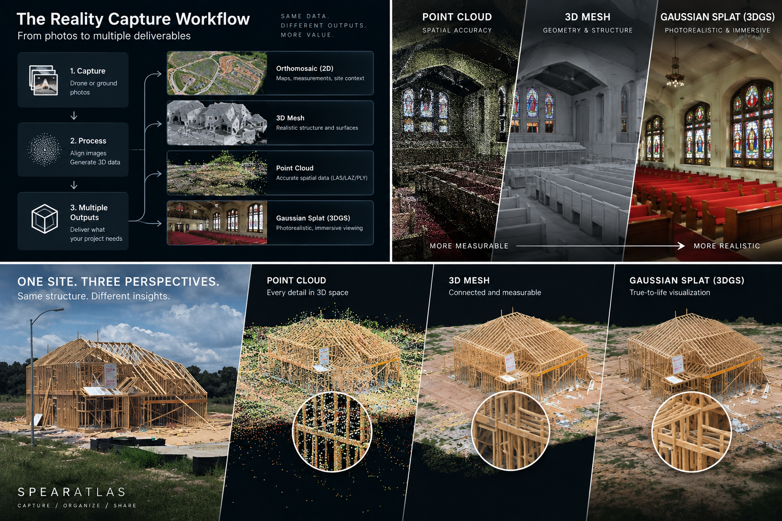
Point cloud versus mesh
The fundamental difference is simple.
Point cloud:
Discrete spatial points.
Mesh:
Connected surface geometry.
The point cloud preserves samples.
The mesh creates surfaces between geometry.
Point cloud versus Gaussian splat
Point clouds prioritize structured spatial information.
Gaussian splats prioritize scene appearance.
A point cloud may be preferable when someone needs:
- Coordinates
- Classification
- Elevation analysis
- Surface generation
- Engineering integration
A Gaussian splat may be preferable when someone needs:
- Visual realism
- Immersive review
- Scene recognition
- Easy stakeholder understanding
Mesh versus Gaussian splat
Meshes represent explicit geometry.
Gaussian splats represent rendered appearance.
A mesh may be preferable when:
- Surface geometry matters
- Standard 3D formats are required
- Measurements are needed
- Models need to enter other 3D workflows
A Gaussian splat may be preferable when:
- Visual fidelity is the priority
- The scene contains complex fine detail
- A realistic walkthrough matters more than conventional topology
Which looks the most realistic?
Often, Gaussian splats can produce extremely convincing visual results.
However, this depends heavily on:
- Capture quality
- Image coverage
- Training or reconstruction
- Scene complexity
- Viewer implementation
A high quality textured mesh can also be highly realistic.
Visual appearance should not be confused with spatial reliability.
Which is best for measurement?
There is no universal answer.
Point clouds and meshes can both support measurement when produced within an appropriate mapping workflow.
The important factors include:
- Capture methodology
- Scale
- Positioning
- Coordinate system
- Control
- Calibration
- Processing
- Quality assurance
- Verification
The presence of a measurement button does not make a dataset suitable for engineering or survey decisions.
Gaussian splats should not automatically be treated as measurable survey geometry.
Which is best for visualization?
For general visualization:
Meshes are highly effective because they create recognizable continuous surfaces.
Gaussian splats can provide even stronger photorealistic scene representation in many environments.
Point clouds can also be visually useful, but they are often less intuitive for nontechnical viewers.
Which is best for CAD or engineering?
Point clouds are commonly used as spatial references in:
- CAD
- BIM
- Engineering
- Surveying
- Existing conditions workflows
Meshes can also enter some design and visualization workflows.
Gaussian splats currently fit less naturally into traditional engineering software.
This does not make one representation superior.
It reflects the different problems they were designed to solve.
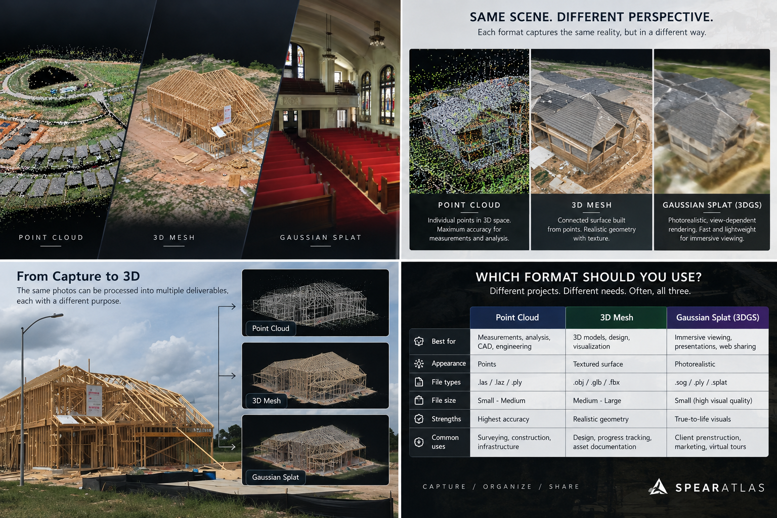
Which is best for construction?
Construction projects may benefit from all three.
Point cloud:
Detailed spatial record.
Mesh:
Easy three dimensional site interpretation.
Gaussian splat:
Highly realistic remote walkthrough.
The project goal determines which outputs provide value. Drone mapping for construction often needs a mesh people can read and a cloud people can measure. Construction teams should not have to choose only one if the capture supports more than one.
Which is best for inspections?
Inspection workflows often benefit from visual context.
A textured mesh can help the reviewer understand:
- Where a defect exists
- How an asset is shaped
- How surfaces relate
Gaussian splats can provide strong visual realism.
Point clouds can provide spatial measurements and geometry.
High resolution source photographs may still be required for detailed defect inspection.
3D representations do not replace the source imagery automatically.
Which is best for vegetation?
Vegetation is difficult for traditional photogrammetric meshes.
Leaves and branches create complicated geometry.
Point clouds can represent vegetation spatially but may appear noisy.
Gaussian splatting can often represent its visual appearance more naturally.
For terrain extraction under vegetation, however, sensor choice and ground visibility remain more important than visual representation.
Which is best for buildings?
Buildings can work well in all three forms.
Point clouds provide spatial structure.
Meshes provide continuous surfaces.
Gaussian splats provide visual realism.
The desired downstream workflow determines which representation is more useful.
File size
All three representations can become large.
Point cloud size depends on factors including:
- Point count
- Attributes
- Compression
Mesh size depends on:
- Polygon count
- Texture resolution
- Number of texture images
Gaussian splat size depends on:
- Number of Gaussian primitives
- Stored attributes
- Compression
- Representation format
Large file size is not unique to any one type of 3D data.
Browser viewing
Modern web applications can display all three representations when the appropriate rendering technology is available.
Browser viewing can make complex reality capture data easier for clients to access without requiring specialized desktop software.
The native source data can still remain available for technical users. Drone operators often need both: a view anyone can open, and files a specialist can still download.
Native data versus presentation
A useful delivery strategy separates two ideas:
What data needs to be preserved?
How should people review it?
A technical user may require:
- LAS or LAZ
- PLY
- OBJ
- GLB
- Other native formats
A client may simply need to open the project and understand the site.
Professional delivery can support both requirements. How to share mapping deliverables with a client is the last mile of that problem.
Why screenshots are not replacements
A screenshot of a point cloud is not the point cloud.
A screenshot of a mesh is not the mesh.
A video of a Gaussian splat is not the interactive scene.
Screenshots and videos are useful for communication.
They should not automatically replace the underlying deliverable when the native spatial data is required.
One site, multiple representations
The same capture may produce several representations.
For example, a photogrammetry mission could generate:
- Point cloud
- 3D mesh
- Orthomosaic
- DSM
- Source imagery
Another processing workflow may also produce a Gaussian splat from overlapping imagery.
These do not need to compete.
They can complement each other.
Why one deliverable is often not enough
Different stakeholders ask different questions.
Engineer:
Where is this feature?
Project manager:
What changed on site?
Owner:
What does the project look like?
Reality capture technician:
What source geometry exists?
Inspector:
Where is the observed condition?
One representation rarely answers every question equally well.
A practical comparison
| Representation | Primary strength | Best suited for | Common formats | Visual realism | Surface continuity |
|---|---|---|---|---|---|
| Point cloud | Spatial point data | Measurement, engineering context, classification, spatial analysis | LAS, LAZ, PLY, E57, and others depending on workflow | Moderate | No explicit continuous polygon surface |
| Mesh | Continuous geometry | 3D visualization, surface representation, measurement, inspection context | OBJ, GLB, glTF, PLY, and others | High when textured well | Yes |
| Gaussian splat | Photorealistic scene representation | Visual walkthroughs, existing conditions, stakeholder review | PLY, SPLAT, SOG, and other ecosystem formats | Potentially very high | Not represented as a conventional polygon mesh |
Format names for Gaussian splats vary by software. A Gaussian PLY is not the same thing as a point cloud PLY or a mesh PLY, even when the extension matches.
Can you convert between them?
Some representations can be derived from others.
A point cloud can contribute to mesh generation.
Meshes can sometimes be sampled into points.
Gaussian splats can potentially be processed into other forms using specialized workflows.
However, conversion does not magically recover information that was not preserved.
Converting representations can change:
- Geometry
- Density
- Topology
- Attributes
- Appearance
- Metadata
- Accuracy context
Keep original source data when it matters.
Photogrammetry workflows
Photogrammetry commonly produces:
- Sparse reconstruction
- Dense point cloud or depth information
- Mesh
- Texture
- Orthomosaic
- Elevation models
The exact pipeline depends on the software.
Gaussian splatting introduces another possible representation built from image observations.
These outputs should be understood as different products rather than interchangeable export buttons.
LiDAR workflows
LiDAR directly produces spatial measurements that naturally form point clouds.
Those point clouds can later be processed into:
- Meshes
- Terrain surfaces
- CAD geometry
- Other derived products
Gaussian splatting may be combined with imagery or other workflows for visualization, but it does not replace the original LiDAR observations.
Reality capture delivery
A reality capture project might contain:
- Point cloud
- 3D mesh
- Gaussian splat
- Orthomosaic
- Photographs
- Video
- PDF report
- CAD files
- Other supporting documents
The strongest delivery method preserves the role of each representation.
Do not flatten everything into one format simply because that format is easy to share.
Choosing the right deliverable
Choose a point cloud when:
Spatial points and associated information matter.
The project enters GIS, CAD, BIM, surveying, or engineering workflows.
Classification or surface extraction is required.
Choose a mesh when:
Continuous surface geometry matters.
Users need intuitive three dimensional visualization.
The model enters conventional 3D workflows.
Choose a Gaussian splat when:
Photorealistic visual reconstruction is the priority.
Stakeholders need an immersive understanding of the captured environment.
Complex visual details are difficult to communicate through a traditional mesh.
When to deliver more than one
Many serious projects should not force a single choice.
A reality capture delivery could include:
- Point cloud for technical users
- Mesh for surface based review
- Gaussian splat for visual navigation
- Orthomosaic for plan view
- Source photos for detailed inspection
- Report for project context
Each format answers a different question.
Organizing multiple 3D deliverables
Multiple representations create a project management problem.
If the point cloud lives in one viewer, the mesh in another, the splat in another, photographs in a folder, and reports in email, the captured site becomes fragmented.
The technical formats may all be correct.
The project experience is not.
Keep the different representations associated with the same site and capture event.
Browser based delivery
Browser viewing can reduce the barrier between technical reality capture data and the people who need to review it.
A client should not necessarily need to understand:
- LAS software
- Mesh import settings
- Gaussian splat renderers
- File dependencies
to understand the captured site.
The native data still matters.
The browser experience provides another layer for review.
The correct representation depends on the question
There is no winner between point clouds, meshes, and Gaussian splats.
They are different ways of describing a captured environment.
Ask:
- Do I need measurable spatial points?
- Do I need continuous surfaces?
- Do I need maximum visual realism?
- Does the client need CAD or GIS compatibility?
- Does the viewer need to understand the site quickly?
- Does the native dataset need to be preserved?
- Does the project require several representations?
The answer determines the deliverable.
Do not confuse realism with accuracy
A highly realistic model can still be spatially inaccurate.
A visually rough point cloud can contain excellent controlled spatial measurements.
Appearance and accuracy are different properties.
That distinction is essential across reality capture.
Do not confuse file format with methodology
An LAS file is not automatically a controlled survey product.
An OBJ file is not automatically accurately scaled.
A Gaussian splat is not automatically unsuitable for every measurement workflow.
The reliability of the project depends on:
- Capture
- Control
- Positioning
- Processing
- Calibration
- Coordinate reference
- Verification
- Intended use
File type describes the representation.
Methodology determines what confidence can be placed in it.
Three representations, three different strengths
Point clouds preserve structured spatial points.
Meshes turn geometry into continuous surfaces.
Gaussian splats prioritize realistic visual appearance.
Modern reality capture workflows increasingly use all three.
The best deliverable is not the one with the newest technology.
It is the one that answers the project question while preserving the information the next person actually needs.